MEOSAR
MEOSARMEOSAR satellites orbit the Earth at an altitude of between 19,000 and 24,000 kms. The satellites are positioned so that there is an overlap of at least 4 satellites for any given region of our planet.
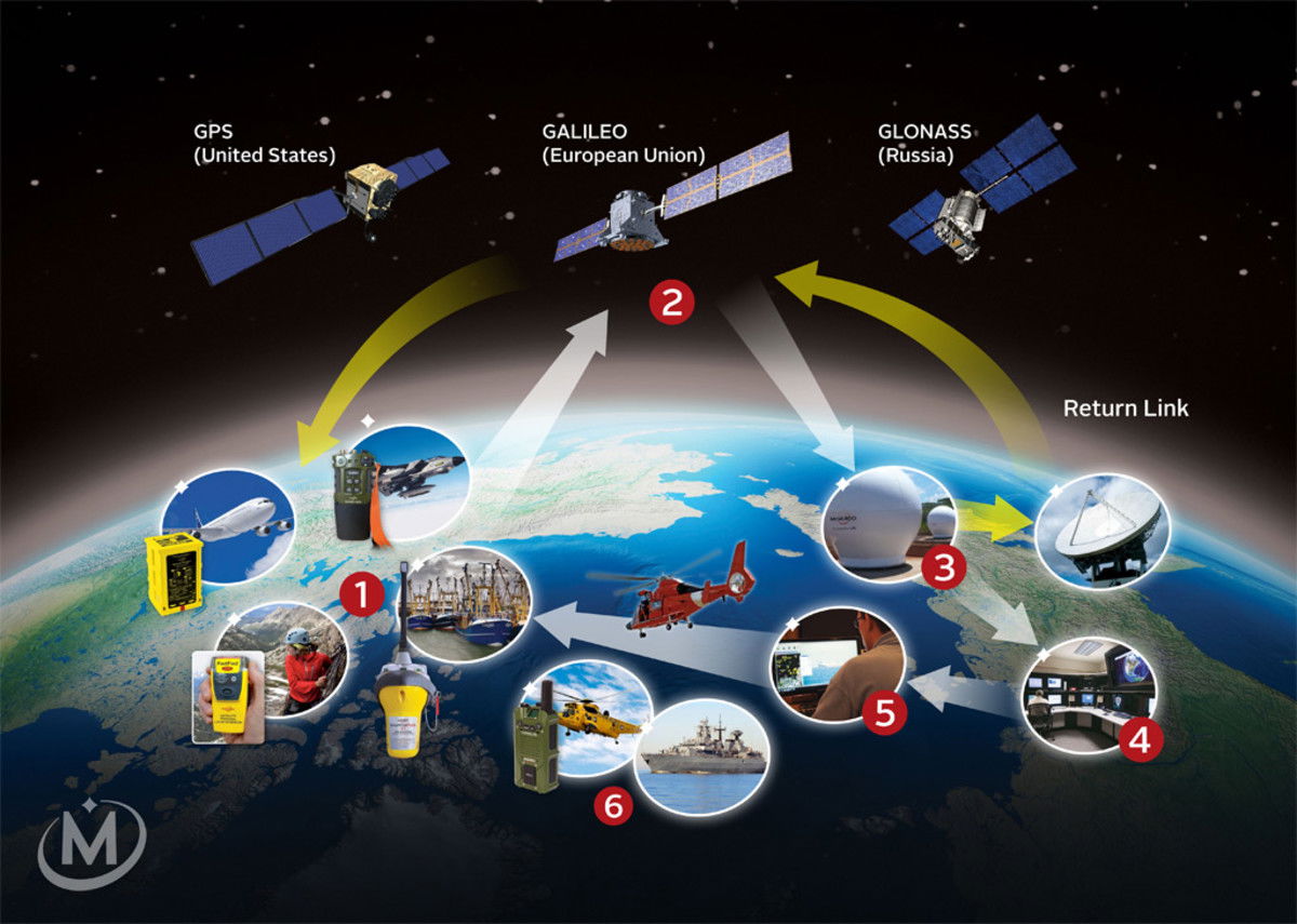
MEOSAR/DASS Concept. – Utilize multiple satellites with SAR repeaters, or “bent pipe”. – Multiple antennas are used to receive the same beacon burst.

Difference between LEOSAR, MEOSAR, GEOSAR

This page compares LEOSAR vs MEOSAR vs GEOSAR and mentions difference between LEOSAR, MEOSAR and GEOSAR.
Introduction :
Cospas-Sarsat program has been designed to protect life and property by providing accurate, reliable and timely alert and location information to search and rescue authorities.
The services are offered free of charge for users in distress across the world.
The alert services are provided with the help of satellites and ground systems by detecting, processing and relaying the transmissions of emergency beacons which operates at RF of 406 MHz.
Based on their altitudes there are about three different types of satellites in Cospas-Sarsat system viz. LEOSAR, MEOSAR and GEOSAR.
What is LEOSAR ?
• LEOSAR stands for Low Earth Orbiting Search and Rescue. It locates beacons using doppler shift processing.
• The system uses 6 satellites on orbit which provides global coverage twice per day.
• The altitude of satellites is about 500 miles in Pole-Pole orbit.
• Performs doppler locating function, Primary means of locating and not GPS.
• LEOSAR stores and forwards alerts continuously for 48 hours.
What is MEOSAR ?
• MEOSAR stands for Medium Earth Orbit Search and Rescue
. The search and rescue receivers are located on GPS satellites
operated by US, Russia and Europe.
• The system offers improved position accuracy and decrease in waiting time.
• These satellites are placed at altitude of about 19000 to 24000 Km.
• MEOSAR system offer sglobal coverage. It provides near instantaneous detection and location informations.
• MEOSAR uses three or more satellites which receive beacon signal and uses trilateration method to calculate a location.
What is GEOSAR ?
• GEOSAR stands for Geostationary Orbiting Search and Rescue. It does not have doppler capability.
• The system uses 5 satellites on orbit.
• The altitude of satellites is about 23000 miles in fixed orbit.
• GEOSAR performs instantaneous alerting function. No locating capability unless beacon is equipped with GPS.
• Coverage from 70N - 70S.
• GEOSAR system does not cover polar areas.
Difference between LEOSAR, MEOSAR and GEOSAR
Following table mentions difference between LEOSAR, MEOSAR and GEOSAR.
| Comparison parameters | LEOSAR | MEOSAR | GEOSAR |
|---|---|---|---|
| • Full Form | Low Earth Orbiting Search and Rescue | Medium Earth Orbit Search and Rescue | Geostationary Orbiting Search and Rescue |
| Altitude | 500 miles | 11800 to 14900 miles | 23000 miles |
| Number of satellites in orbit | 6 | 5 | 3 |
| Worldwide coverage | Yes | Yes | No polar coverage |
| Real time continuous access | No, latency up to several hours until satellite pass, and then potential latency until downlink | Yes | Real time continuous access on covered area but with a less favorable link budget compared to MEOSAR |
| Number of satellites simultaneously in visibility | Most of the time, no satellite in view, and in general only one satellite at a time (except for polar areas where multiple visibilities can occur). | More than 10 satellites in visibility at anytime and anywhere | Only 1 or 2 satellites in view and therefore important impacts masking effects |
| Independent localization of fast moving beacons | Not available | Available | Not available |


